Wednesday, July 1, 2015

Exploring SE Utah (Natural Bridges, Canyonlands, Arches, and Moab)

Along the road to Moab we passed through Mexican Hat and stopped at Natural Bridges. The "street sign" announcing Mexican Hat is up on the hillside.  Pat managed to catch it as we drove by.  


Mexican Hat Rock Formation
Our first stop was at the Mule Canyon Ruin, where we learned a bit more about the Anasazi, residents of the area until 900AD. It was unclear when the Ruin is from but we suspect it is from the Anasazi Pueblo III period (AD 1100 - 1300). There was an adjoining tower connected to an underground ceremonial Kiva which would have been entered via a hole in the roof. The tower may have been used for defensive, astronomical or ceremonial purposes.
Kiva at Mule Canyon
We continued on to the Natural Bridges National Monument. The main feature here is 9 mile scenic loop road that leads to trails and views of 3 large natural "bridges", Sipapu, Kachina, and Owachomo, as well as to the Horse Collar Ruin. (Later we would visit "arches". They look the same to a naive viewer. But a bridge is formed by the water and an arch is formed by erosion.) 


Horse Collar Ruin viewed from across the canyon
Owachomo Bridge...it looks like a roadway but as you study it you can see the opening belos.
After arriving in Moab we went shopping for a welcoming dinner for our friends Peter & Peggi (who live in Denver) and Steve & Sarah (who are currently splitting their time between Miami & California). They met up in Denver and drove to Moab to join us for the tour of the area. We were fortunate to have Steve, he is quite familiar with the area and helped set our touring priorities.

The tour began early the next morning at Arches with a three mile round trip hike to Delicate Arch. 
At Delicate Arch
At Devil’s Garden a short walk brought us to Pine Tree Arch. 
Pine Tree Arch
Peter & Steve along the trail
With the afternoon heat at 105F, we decided to have lunch and take it easy for the afternoon. Later, Bill, Pat, Sarah and Steve went to Dead Horse Point and Islands in the Sky in Canyonlands National Park and concluded the day with a picnic at sunset. 

The roads around these two parks cross some very narrow necks of land where you can see down on both sides of the car. The spectacular canyons carved by the Colorado River and the very colorful sunset generated a few more photos.


View over Canyonlands "Island in the Sky" District in the late afternoon sun.
View over the river in Canyonlands
The next day we were off to the Needles section of Canyon Lands. Enroute we stopped to appreciate the petroglyphs at Newspaper Rock, so named due to the many stories recorded in petroglyphs.


The Needles area of Canyonlands NP features never ending varieties of rock formations and canyons. The trail at Cave Spring led us to the overhangs where camps were established for the cowboys tending the herds around 1900.


Remains of a Cowboy Camp at Cave Spring
We enjoyed the whimsical naming of the "Wooden Shoe Arch".

We hiked to the first two view points along Slickrock Trail for some spectacular views.
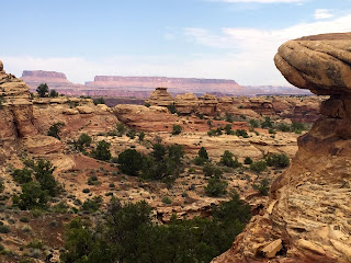

A view from Slickrock
Around Elephant Hill we found the the best views of the Needles landscape and a spot for a picnic lunch. 
Needle Formation from Elephant Hill area


Dinner in Denver included Peter and Peggi’s neighbors Rob and Kim. …Life in a church.  Get a photo.

No comments:

Post a Comment